


Projet TMB 2024 Contamines Montjoie/Courmayeur

Laurence Lallemand
User
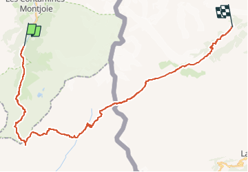

Length
34 km

Max alt
2664 m

Uphill gradient
2295 m
Km-Effort
64 km

Min alt
1214 m

Downhill gradient
2007 m
Boucle
No
Creation date :
2023-03-01 20:46:41.98
Updated on :
2023-03-01 20:48:25.44
14h30
Difficulty : Very difficult

FREE GPS app for hiking
 SityTrail
IGN / Geographical institutes
SityTrail Plus
The world is yours!
About
Trail Walking of 34 km to be discovered at Auvergne-Rhône-Alpes, Upper Savoy, Les Contamines-Montjoie. This trail is proposed by Laurence Lallemand.
Positioning
Country:
France
Region :
Auvergne-Rhône-Alpes
Department/Province :
Upper Savoy
Municipality :
Les Contamines-Montjoie
Location:
Unknown
Start:(Dec)
Start:(UTM)
322495 ; 5073437 (32T) N.
Comments